


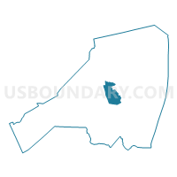
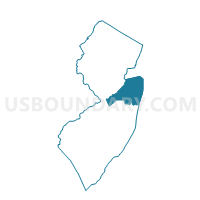
Colts Neck township voting district 2, Monmouth County, New Jersey
About
Outline

Summary
| Unique Area Identifier | 620554 |
| Name | Colts Neck township voting district 2 |
| County | Monmouth County |
| State | New Jersey |
| Area (square miles) | 13.09 |
| Land Area (square miles) | 12.63 |
| Water Area (square miles) | 0.46 |
| % of Land Area | 96.48 |
| % of Water Area | 3.52 |
| Latitude of the Internal Point | 40.28705590 |
| Longtitude of the Internal Point | -74.15244570 |
Maps

Graphs
Select a template below for downloading or customizing gragh for Colts Neck township voting district 2, Monmouth County, New Jersey


Neighbors
Neighoring Voting District (by Name) Neighboring Voting District on the Map
- Colts Neck township voting district 1, Monmouth County, NJ
- Colts Neck township voting district 3, Monmouth County, NJ
- Colts Neck township voting district 5, Monmouth County, NJ
- Colts Neck township voting district 8, Monmouth County, NJ
- Holmdel township voting district 5, Monmouth County, NJ
- Howell township voting district 27, Monmouth County, NJ
- Middletown township voting district 5, Monmouth County, NJ
- Tinton Falls borough voting district 1, Monmouth County, NJ
- Tinton Falls borough voting district 2, Monmouth County, NJ
- Wall township voting district 15, Monmouth County, NJ
Top 10 Neighboring County Subdivision (by Population) Neighboring County Subdivision on the Map
- Middletown township, Monmouth County, NJ (66,522)
- Howell township, Monmouth County, NJ (51,075)
- Wall township, Monmouth County, NJ (26,164)
- Tinton Falls borough, Monmouth County, NJ (17,892)
- Holmdel township, Monmouth County, NJ (16,773)
- Colts Neck township, Monmouth County, NJ (10,142)
Top 10 Neighboring Place (by Population) Neighboring Place on the Map
Top 10 Neighboring Elementary School District (by Population) Neighboring Elementary School District on the Map
- Howell Township School District, NJ (51,075)
- Tinton Falls Borough School District, NJ (19,033)
- Colts Neck Township School District, NJ (10,142)
Top 10 Neighboring Secondary School District (by Population) Neighboring Secondary School District on the Map
Top 10 Neighboring Unified School District (by Population) Neighboring Unified School District on the Map
- Middletown Township School District, NJ (66,522)
- Wall Township School District, NJ (26,164)
- Holmdel Township School District, NJ (16,773)
Top 10 Neighboring State Legislative District Lower Chamber (by Population) Neighboring State Legislative District Lower Chamber on the Map
- General Assembly District 30, NJ (270,300)
- General Assembly District 12, NJ (235,457)
- General Assembly District 13, NJ (219,626)
- General Assembly District 11, NJ (205,526)
Top 10 Neighboring State Legislative District Upper Chamber (by Population) Neighboring State Legislative District Upper Chamber on the Map
- State Senate District 30, NJ (270,300)
- State Senate District 12, NJ (235,457)
- State Senate District 13, NJ (219,626)
- State Senate District 11, NJ (205,526)
Top 10 Neighboring 111th Congressional District (by Population) Neighboring 111th Congressional District on the Map
Top 10 Neighboring Census Tract (by Population) Neighboring Census Tract on the Map
- Census Tract 8048, Monmouth County, NJ (9,727)
- Census Tract 8033, Monmouth County, NJ (6,600)
- Census Tract 8111.02, Monmouth County, NJ (6,215)
- Census Tract 8086, Monmouth County, NJ (6,213)
- Census Tract 8015, Monmouth County, NJ (6,135)
- Census Tract 8099.01, Monmouth County, NJ (5,227)
- Census Tract 8099.02, Monmouth County, NJ (4,690)
- Census Tract 8046, Monmouth County, NJ (2,881)
- Census Tract 8099.03, Monmouth County, NJ (225)
Top 10 Neighboring 5-Digit ZIP Code Tabulation Area (by Population) Neighboring 5-Digit ZIP Code Tabulation Area on the Map
- 07712, NJ (39,158)
- 07753, NJ (37,554)
- 07724, NJ (21,710)
- 07733, NJ (16,849)
- 07722, NJ (10,209)
- 07727, NJ (7,050)
- 07738, NJ (6,095)